Under the Lee-Russell Council of Governments, the Auburn-Opelika Metropolitan Planning Organization is in the process of developing a 25-year plan in order to tackle issues regarding Auburn’s transportation and infrastructure.
The AOMPO will make the decisions along with Alabama Department of Transportation on what transportation projects should be funded with the available local, state and federal dollars.
The 25-year plan, also called the 2045 Long Range Transportation Plan, is a roadmap that will address the region’s transportation needs over the next 25 years. It aims to provide reliable transportation options, improve safety and maintain and maximize the transportation system in Auburn.
The AOMPO is now working with Neel-Shaffer, a management firm that specializes in engineering, construction and planning, to create the plan.
Vijay Kunada, the vice president and engineering manager of Neel-Shaffer, discussed the necessity of the plan during an open house for the plan on Tuesday, Feb. 4.
“First of all, it is good to have a plan,” Kunada said. “But the main thing is that it’s a federal requirement. If you do want to receive any kind of federal funds to support the transportation system in this area, you need to have a plan.”
The AOMPO open house also provided staff members working on the plan the opportunity to hear from members of the public and gather data and input. Kunada explained where the plan is heading and outlined their most vital focuses to visitors.
“We have taken into account the rate of household growth and job growth in the Auburn area in order to predict the needs for the next 25 years,” Kunada said. “Once we know the growth, we can look at the needs — things such as roadways, bike paths, pedestrians, public transit and freight.”
He continued by specifying one of the main focuses of the plan.
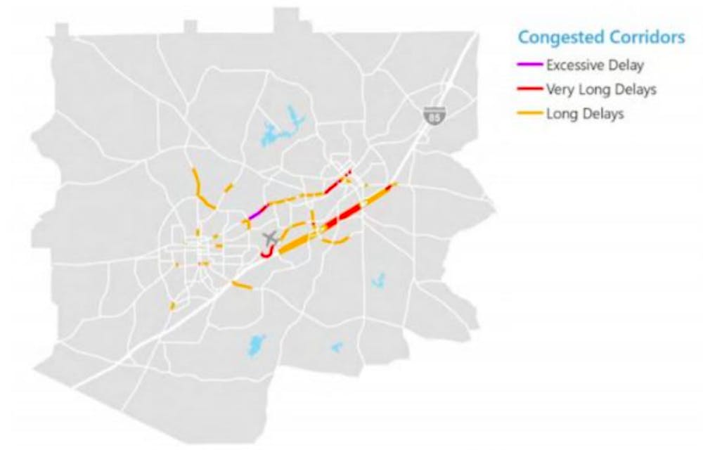
“Certain areas in Auburn are much more congested than other areas, and that can cause a lot of danger and inconsistency,” Kunada said. “We can use our funds to do things in that area, such as widening the roads, adding turning lanes or adding a new roadway.”
Kunada said there is a need for a public transit system in the Auburn area.
“In Auburn, there is no public transit,” Kunada said. “There is Tiger Transit, but that is limited to students, and in Opelika, we actually do have public transportation, but not many people know about it. It’s called Dial-A-Ride, and how it works is you call the number and you will be picked up. But there is no set route, like a bus, so we are working towards establishing that.”
With the plan implemented, Kunada said that by 2045, the extra time congested roads add to residents’ commutes will decrease by about 15%.
“Our main goal of the plan in regards to the roadways is to maximize all of our assets,” Kunada said. “With the $190 million grant, we want to be able to do the most with that amount. We want to establish a consistent commute with drivers and also improve citizens’ desire for transportation and safety.”
Do you like this story? The Plainsman doesn't accept money from tuition or student fees, and we don't charge a subscription fee. But you can donate to support The Plainsman.